


- MENU
- Store Info
-
Inventory
-
New Equipment
-
All Products
- Ag Leader
- AGI GrainVacs
- Art's Way
- Berlon Attachments
- Bradco
- Brent
- Capello USA
- Curtis Cabs
- Degelman
- Demco
- DeWalt
- Diamond Mowers
- Drago
- Echo
- Farm King
- Great Plains
- Hardi
- Haybuster
- Henke Buffalo
- Hiniker
- Kuhn
- Land Pride
- MacDon
- McFarlane
- Meyer Farm Equipment
- Miller Nitro Sprayers
- Orange Aftermarket
- Orthman
- Norden Mfg.
- Peck Manufacturing
- Quicke
- Smucker
- Trimble
- TROY-BILT
- Unverferth
- Yetter
-
Departments
- Rentals
-
Company
-
Specials
-
Online Store
-
Locations
- Case IH Combines

Trimble FieldLevel II system
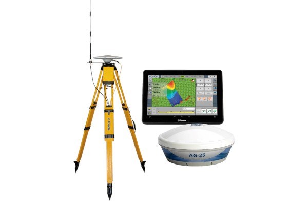
FieldLevel II system
FieldLevel™ II is a comprehensive solution that streamlines surveying, designing and land-forming activities.
- Get a Quote
- Send to a Friend
- Payment Calculator
-
Schedule Demo
Schedule A Demo
Fields with asterisks* are required.
Get A Quote
Fields with asterisks* are required. Please email our helpful staff with any questions or comments using the contact form.
Send To A Friend
Fields with asterisks* are required. Your friend will receive an email that contains a reference to this page. Please send this email only to people you know who would be interested in this information.
Loan Calculator
Use the Loan Calculator to help you determine the financing and payment options that are best for you.
**The accuracy of this calculator and its applicability to your circumstances is not guaranteed. You should obtain personal advice from qualified professionals. This information is provided for illustrative purposes only and does not constitute an application. This notice does not guarantee loan approval, nor is it an offer or commitment to make a loan to you on the above terms.
Features
Land forming from beginning to end
With Trimble solutions, you can simplify every step of the land forming process, including surveys, analysis, design, estimates, forming and verification.
Benefits and performance
Trimble’s water management solutions – including tools for both land forming and drainage projects – aim to help you make the best use of this invaluable resource. Here are a few of the benefits the FieldLevel II system delivers.
Improve yields and minimize costs by controlling excess water
Use any equipment make or model to grade fields
FieldLevel II System
For land forming
Survey:
- Precisely map fields with RTK precision
- Create boundaries, interior points, and surfaces with ease
- Calculate and report on the true area of your survey for optimal field coverage and accurate surface designs
Design:
- Create a best-fit surface using Autoplane technology
- Define primary and cross slopes for prescribed orientation and grades
- Use Multiplane technology for more complex field requirements
Form:
- Automatically drive the scraper hydraulic valves on any type of tractor and scraper to level your fields
- Operate both tandem and dual scraper systems to increase the productivity of your land forming projects
FieldLevel II System
For levee creation
Complete levee solution
- Survey:
- Capture 3D topography data using the FieldLevel II module on the TMX-2050 display
- Design:
- Analyze field shapes using 3D view, contours, flow arrows and tributary information within WM-Subsurface software
- Define starting point, vertical intervals, and turn radius capability and WM-Form software will determine the optimal levee location
- Installation:
- Use your Autopilot™ steering system to accurately guide your tractor as levees are installed
Using a contour
- Survey:
- Use FieldLevel II to manually mark levees along field contours
- Design:
- Define the start point of your levee in your Trimble display
- Installation:
- Allow your Trimble display to guide you as you mark perfect levees along the contour
- Decrease time and difficulty associated with marking a levee by changing the blade step up or down as you move from one contour to another
- Includes FieldLevel II Survey and Design module installed on TMX-2050™ display
- Leveling components installed directly to the tractor’s hydraulic system or onto grading equipment
- 2D and 3D design options
- Options for complete levee design/guidance or manual guidance along a contour
-
Preston, IA
Directions
Monday-Friday : 7:30am to 5pmSaturday : 7:30am to 12pmSunday : Closed all day -
DeWitt, IA
Directions
Monday-Friday : 7:30am to 5pmSaturday : 7:30am to 12pmSunday : Closed all day
© Copyright 2026 Kunau Implement All Rights Reserved - Site by EquipmentLocator.com
Asterisks * are required.
Join our mailing list and get the latest news and special offers!
Sign Up
